
By Rachel Nisbet
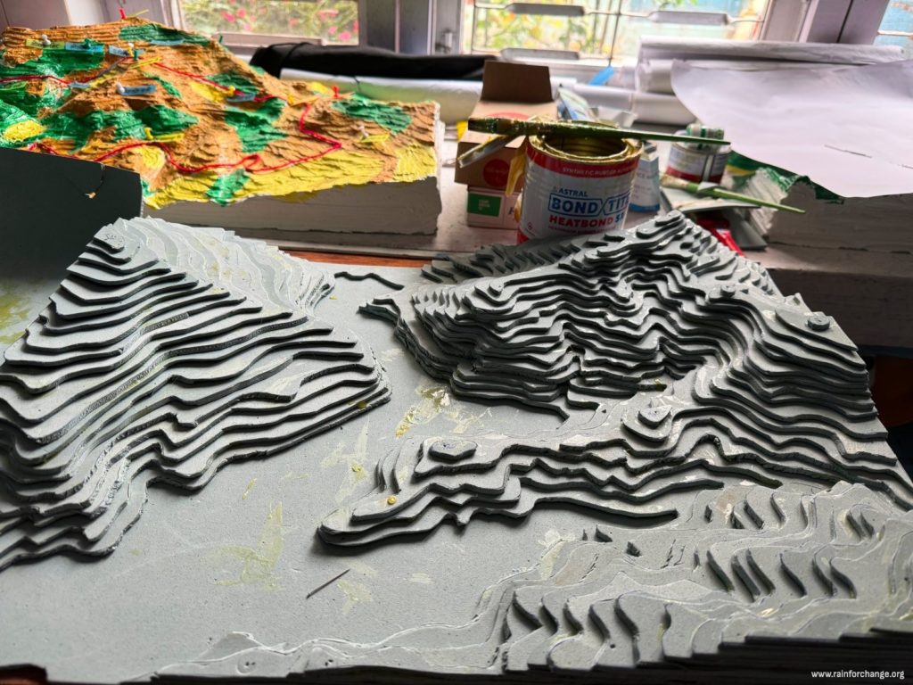
Making participatory maps to talk about water
Creating an integrated water resources management plan involves many community-based organisations. In our project in Nepal with Kanchan Nepal, we work with mothers’ groups, youth clubs, water user committees, cooperatives, farmers’ groups and forest user groups, to get communities thinking about how their water supply depends on both groundwater flow and rainfall.
To build local water wisdom, we need a common language to talk about how water flows through the landscape. A hydraulic engineer and a homemaker experience water differently. Making maps and telling stories about the land are two ways of helping them exchange what they know.
We are making two participatory maps to support this conversation: one for the Kalika–Thulakot–Begnas area, around the city of Pokhara, and one for the rural Rupakot–Thumki–Hansapur area in Rupa municipality.
To prepare a Water Use Master Plan (WUMP) for these areas, we will meet local leaders, teachers, students and the community groups mentioned above. Using our 3D maps, we will ask participants to show where natural resources are, including water bodies (springs, ponds, rivers and streams), forests, barren land and farmland, and then record this information topographically. We will also ask them to show paths, roads and public buildings such as schools, clubs, hospitals, temples and government offices. Until now, WUMP approaches have used 2D maps. Our project will make it easier for people to relate to a map by showing them a 3D model of their area. When people share local knowledge as stories, we can map these too. Telling the story of the land in this way will help us address the water scarcity and erosion that local communities face, and offer practical solutions.
Eating ecosystem-based adaptation
Our project will help people appreciate the value of rain all the way to the dining table. So far, local communities have used their forests only minimally, for firewood, cattle fodder and timber. The new sections of forest we will plant with the forest user group network FECOFUN will supply food and medicines as well. We are developing nurseries, so that when we plant erosion-prone slopes, the species will include herbal plants, fruiting shrubs and fodder trees. Plants such as amla (Phyllanthus emblica) have culinary value: their fruits are used in pickles and as herbal medicines. It is exciting that local communities will taste the benefits of our integrated water resources management plan within a few growing seasons.
One potential challenge, however, is that forest management is being questioned in Nepal. The 1993 Forest Act gave villagers the mandate to protect, manage and use their forests. Today, there are concerns that forest resources should contribute more directly to the economy, which points towards more centralised forest management. We are confident, however, that our collaboration with FECOFUN in Kaski District will show that local forest management brings economic and ecosystem benefits. Planting carefully chosen tree species on erosion-prone slopes can reduce the risk of landslides, raise groundwater levels and provide local communities with valuable water, food and fuel.
Read more on the project page: Rain Communities Nepal – Phase 1.
First published on the former IRHA website on 27 February 2020.